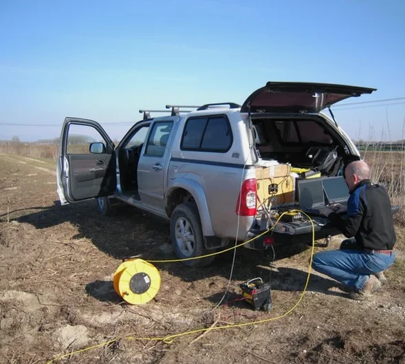
Geophysics in Coffs Harbour encompasses a suite of non-invasive subsurface investigation techniques that allow engineers, developers, and environmental consultants to visualise what lies beneath the ground without breaking it. From the coastal plains to the steep hinterland escarpments, these methods are critical for de-risking construction, locating buried utilities, and assessing geological hazards. A typical geophysical campaign in the region might combine a GPR (Ground Penetrating Radar) survey to map shallow concrete structures and voids with deeper electrical or seismic methods to characterise bedrock and soil stratigraphy. The value of these investigations lies in their ability to cover large areas quickly, providing continuous subsurface profiles where boreholes alone would leave gaps, a crucial advantage in a landscape shaped by ancient volcanic activity and dynamic coastal processes.
The local geology of Coffs Harbour presents a compelling case for integrated geophysics. The region sits on a complex basement of Palaeozoic metasediments and granites of the New England Orogen, overlain in many areas by Tertiary basalt flows that form the prominent ridgelines of the Great Dividing Range. Coastal zones feature Quaternary alluvial and estuarine sediments, often interbedded with soft clays and saturated sands that can amplify seismic waves. These conditions create a challenging environment where rapid lateral changes in lithology are common. A Vertical Electrical Sounding (VES) or continuous resistivity profile can distinguish between conductive marine clays and resistive basalt bedrock, while HVSR microtremor surveys using the Nakamura method measure the fundamental resonance frequency of soft sediments, a direct proxy for depth to bedrock and a key input for seismic site classification.
Compliance with Australian standards is mandatory for any geophysical work intended to inform geotechnical models or structural design. All practitioners in Coffs Harbour must align their reporting with AS 1726:2017 for geotechnical site investigations, which references geophysical methods as supplementary tools for ground characterisation. For seismic hazard assessment, AS 1170.4:2007 (Structural design actions – Earthquake actions in Australia) governs the determination of site sub-soil classes, a task where HVSR microtremor surveys are explicitly recognised as a valid technique to derive Vs30 profiles when combined with other methods. GPR surveys must adhere to guidelines from the Australian Society for Exploration Geophysicists (ASEG) and, where utilities are involved, to the requirements of Dial Before You Dig (DBYD) and AS 5488.1:2019 for the classification of subsurface utility information. All resistivity and seismic data should be acquired following ASTM International standards, such as D6431 for electrical resistivity imaging and D7128 for seismic refraction, ensuring defensible results for council submissions and development approvals.
The types of projects in Coffs Harbour that require geophysical input are diverse and growing. Coastal infrastructure, including the harbour breakwater, marina developments, and stormwater outfalls, demands high-resolution GPR surveys to map concrete thickness, rebar patterns, and potential scour voids. Hillslope residential subdivisions on the northern and western fringes often trigger the need for seismic refraction tomography to determine rippability and depth to fresh rock, directly influencing earthworks costs and retaining wall design. Major transport corridors like the Pacific Highway upgrade projects have historically relied on electrical resistivity imaging to delineate soft alluvial channels and paleochannels that could cause differential settlement. Environmental assessments for landfill expansions or groundwater monitoring equally depend on geophysics to map contaminant plumes and locate the water table, ensuring compliance with NSW Environment Protection Authority (EPA) guidelines.
Geophysics provides continuous subsurface profiles between and beyond borehole locations, revealing lateral variations in rock and soil that isolated point data can miss. In Coffs Harbour's complex geology, where basalt flows and alluvial channels shift abruptly, this continuous coverage is essential for identifying hidden voids, variable bedrock depths, and soft sediment pockets that could lead to uneven settlement or slope instability.
Geophysical methods used for geotechnical site characterisation must comply with AS 1726:2017, while seismic site classification for earthquake design follows AS 1170.4:2007. Additional relevant standards include the ASEG guidelines for data acquisition, AS 1289 for electrical resistivity, AS 1289 for seismic refraction, and AS 5488.1:2019 for subsurface utility mapping when GPR is employed to locate buried services.
Yes, a combination of techniques is typically used. Seismic refraction or multichannel analysis of surface waves (MASW) quantifies seismic velocities directly related to stiffness, while HVSR microtremor surveys measure the fundamental resonance frequency of soft soils to estimate bedrock depth. Electrical resistivity can further discriminate between weathered and fresh basalt, providing a calibrated ground model for foundation design.
Wet, saturated ground can actually enhance the performance of electrical resistivity surveys by improving electrode coupling and reducing contact resistance, though it may slightly attenuate high-frequency GPR signals. Seismic methods are generally unaffected by moisture. Experienced local practitioners account for seasonal water table fluctuations and saturated clays in their data processing to ensure reliable interpretations year-round.